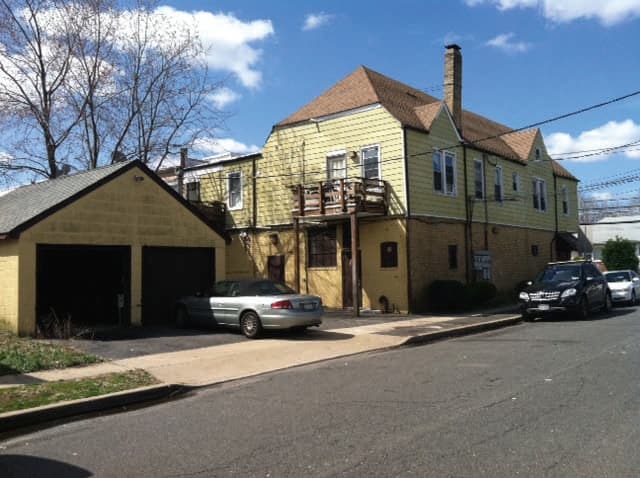
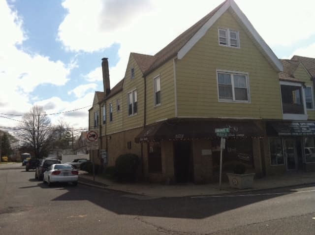
Property Record
2783 Milburn Ave, Baldwin, NY 11510

NEARBY LISTINGS FOR SALE OR LEASE
Property Detail
2783 Milburn Ave
2089-54-481-00-0396-0
TOWN #1 SCH DIST 010
Commercialnec
Nassau
X
New York
36059C0238G
396
2025
0.09 AC
2025
Southern Nassau
413700
Long Island (New York)
9,380 SF
Nassau County-Suffolk County, NY
DEMOGRAPHICS near 2783 Milburn Ave
1 Mile
3 Mile
5 Mile
2024 Total Population
26,407
160,769
416,656
2029 Population
25,965
157,996
408,792
Pop Growth 2024-2029
(1.67%)
(1.72%)
(1.89%)
Average Age
41
41
41
2024 Total Households
8,470
52,082
134,370
HH Growth 2024-2029
(1.76%)
(1.77%)
(1.97%)
Median Household Inc
$120,157
$118,649
$118,825
Avg Household Size
3.00
3.00
3.00
2024 Avg HH Vehicles
2.00
2.00
2.00
Median Home Value
$490,303
$569,803
$602,167
Median Year Built
1952
1952
1953
Nearby Places
Map Layers
Map Styles
 Street
 Aerial
- Restaurants
- Banks
- Shops
- Fitness
- Groceries
PUBLIC TRANSPORTATION
COMMUTER RAIL
Baldwin Station (Babylon Branch - Long Island Rail Road)
DRIVE
WALK
Distance
Baldwin Station (Babylon Branch - Long Island Rail Road)
2 min
1.3 mi
Freeport Station (Babylon Branch - Long Island Rail Road)
DRIVE
WALK
Distance
Freeport Station (Babylon Branch - Long Island Rail Road)
4 min
2.1 mi
AIRPORT
John F Kennedy International
DRIVE
WALK
Distance
John F Kennedy International
20 min
13.1 mi
LaGuardia
DRIVE
WALK
Distance
LaGuardia
31 min
20.1 mi
Long Island MacArthur
DRIVE
WALK
Distance
Long Island MacArthur
43 min
31.9 mi
Freight Ports
NY - Red Hook Container Terminal
DRIVE
WALK
Distance
NY - Red Hook Container Terminal
41 min
24.6 mi
Nearby Properties
Address
Land Use
TOTAL SIZE
Lot Size
Zoning
Address
Land Use
TOTAL SIZE
Lot Size
Zoning
Address
Land Use
TOTAL SIZE
Lot Size
Zoning
5,800 SF
10.48 AC
Address
Land Use
TOTAL SIZE
Lot Size
Zoning
986.74 AC
Address
Land Use
TOTAL SIZE
Lot Size
Zoning
169.25 AC
Address
Land Use
TOTAL SIZE
Lot Size
Zoning
336,450 SF
139.91 AC
Address
Land Use
TOTAL SIZE
Lot Size
Zoning
133.85 AC
Address
Land Use
TOTAL SIZE
Lot Size
Zoning
57,970 SF
1.69 AC
Address
Land Use
TOTAL SIZE
Lot Size
Zoning
80.84 AC
Address
Land Use
TOTAL SIZE
Lot Size
Zoning
65,235 SF
15.48 AC
Address
Land Use
TOTAL SIZE
Lot Size
Zoning
94,204 SF
35.42 AC
Address
Land Use
TOTAL SIZE
Lot Size
Zoning
140,000 SF
50.78 AC
Address
Land Use
TOTAL SIZE
Lot Size
Zoning
151,757 SF
34.38 AC
Address
Land Use
TOTAL SIZE
Lot Size
Zoning
80,895 SF
26.22 AC
Address
Land Use
TOTAL SIZE
Lot Size
Zoning
99,904 SF
20.17 AC
Address
Land Use
TOTAL SIZE
Lot Size
Zoning
20,670 SF
6.62 AC
Address
Land Use
TOTAL SIZE
Lot Size
Zoning
357,868 SF
24.92 AC
Address
Land Use
TOTAL SIZE
Lot Size
Zoning
377,041 SF
14.43 AC
Address
Land Use
TOTAL SIZE
Lot Size
Zoning
140,992 SF
12.07 AC
Address
Land Use
TOTAL SIZE
Lot Size
Zoning
61.52 AC
Address
Land Use
TOTAL SIZE
Lot Size
Zoning
61.52 AC
Address
Land Use
TOTAL SIZE
Lot Size
Zoning
74,813 SF
4.56 AC
Address
Land Use
TOTAL SIZE
Lot Size
Zoning
58.86 AC
Address
Land Use
TOTAL SIZE
Lot Size
Zoning
59,715 SF
12.81 AC
Address
Land Use
TOTAL SIZE
Lot Size
Zoning
168,070 SF
11.29 AC
Address
Land Use
TOTAL SIZE
Lot Size
Zoning
82,698 SF
12.03 AC
Address
Land Use
TOTAL SIZE
Lot Size
Zoning
41,612 SF
3.89 AC
Address
Land Use
TOTAL SIZE
Lot Size
Zoning
37.90 AC
Address
Land Use
TOTAL SIZE
Lot Size
Zoning
278,714 SF
3.04 AC
Address
Land Use
TOTAL SIZE
Lot Size
Zoning
193,285 SF
9.64 AC
Address
Land Use
TOTAL SIZE
Lot Size
Zoning
45,854 SF
2.31 AC
The World's #1 Commercial Real Estate Marketplace
Connect with us
© 2026 CoStar Group
The information above has been obtained from sources believed reliable. While we do not doubt its accuracy we have not verified it and make no guarantee, warranty or representation about it. It is your responsibility to independently confirm its accuracy and completeness. Any projections, opinions, assumptions, or estimates used are for example only and do not represent the current or future performance of the property. The value of this transaction to you depends on tax and other factors which should be evaluated by your tax, financial, and legal advisors. You and your advisors should conduct a careful, independent investigation of the property to determine to your satisfaction the suitability of the property for your needs.